Empowering decision-making for a safer, smarter world
Spatial Analytics-driven 3D Modelling, BIM, and Digital Twin.
Spatially analyze, model, and simulate with 3D technology and Digital Twin
Since 2018, we have been dedicated to our mission of improving decision-making processes to create a safer and smarter world..
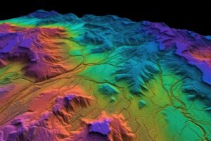
Geospatial
We excel in visualising, editing, and managing geographic data.
BIM
Building the Future: Empowering Construction with BIM Excellence
Digital Twin
Empowering Real-World Optimization with Digital Twins of their assets.
We aim to empower organizations to harness the full potential of GIS for their business objectives. With expertise in geographic data visualization, spatial analysis, and efficient data management, our services cover Spatial Data Management, Lidar and UAV Data Processing, Photogrammetry, 3D City Modeling, and Image Processing.
Streamlining Spatial Data Conversion Satellite Imagery Processing Services Lidar Data Processing for Precise Insights Navigational Video Imagery Processing Seamlessly Integrating Survey Data Transforming Data through ETL Efficient Work Order Cleansing and Posting .
Our BIM services revolutionize project management, enabling seamless collaboration and optimized construction processes. Our expertise in 3D modeling, data integration, and virtual simulations empowers clients to achieve efficient and sustainable building solutions.

Our digital twin platform is at the forefront of innovation, enabling the creation of virtual replicas of physical spaces. By integrating real-time data from various sources, our platform offers a comprehensive understanding of the environment, empowering informed decision-making and strategic planning.

Gain Deep Insights into Your Assets
Visual asset communication unites teams with powerful tools for seamless collaboration..
Industries We Serve
Our Solutions
Telecom

Accelerating Broadband Deployment through OSP Design and GIS Analysis
We accelerates ISP deployment with advanced OSP design and GIS analysis solutions.
Uncover the power of streamlined processes, optimized strategies, and GIS analysis to accelerate broadband deployment, identify expansion opportunities, and achieve efficient network deployment.
Key aspects of our offerings in OSP design engineering include:
Address Database Curation
Utility Route Mapping
Utility Route Classification
Fiber Network Design
Fiber Assignments
Existing Asset Mapping
Transportation
Intelligent Mobility : Driving Innovation
4D4’s data visualization powers shape intelligent mobility, optimizing routes, improving planning, and decision-making for seamless transportation.
Agriculture

Cultivating a Digital Agricultural Revolution
By unleashing the potential of data, 4D4 can drive a digital revolution that revolutionizes farming practices, productivity, and sustainability. Through data-driven insights 4D4 can provide the agriculture industry with a vision to optimize resource allocation, enhance crop yields, and foster sustainable practices.
Our Technology Partners

Why Choose us
Innovate. Excel. Trust. Collaborate
At our core, we embody the values of innovate, excel, trust, and collaborate. These principles drive everything we do and define our approach to business.

Innovation
We constantly push the boundaries of what's possible, delivering ground-breaking solutions that drive growth and transform industries.
Expertise
Our team of experts comprises seasoned professionals with deep domain knowledge, ensuring tailored solutions that meet your unique requirements.
Reliability
We pride ourselves on our commitment to delivering high-quality products and services, on-time and within budget.
Collaboration
We value partnerships and collaboration, working closely with our clients to understand their needs and provide comprehensive support.
Get in touch
Contact our sales
Reach out to us for personalized solutions and prompt assistance.
Services
Industry
Get in touch
- USA:- 960 N. Ohlman, # 12 Mitchell, SD 57301
- UAE:- 3rd Floor, Business Centre Dubai, World Central, PO Box-390667
- info@4d4technologies.com
Copyright © 2023 4D4 , All rights reserved.